Water Quantity
Agriculture is one of the largest users of surface water and groundwater, with irrigation being the greatest use. There are many ways farmers and ranchers can manage excess water, conserve limited supplies of water and build resilience to mitigate drought on their and and in their community.
KACD is committed to working with our partners across the state to address water quantity issues and create a greater awareness of our water quantity concerns through outreach and education.
KACD and our local districts provide:
- Field days
- Host farmer-to-farmer conversations
- Educational materials
- Various demonstration tools, such as rainfall simulator, stream trailer, groundwater flow models and enviroscapes, etc
Principles of Water Quantity
Resources and opportunities for education can be found at many of our partners web pages.
United States Department of Agriculture:
https://www.farmers.gov/conservation/water-quantity
Natural Resources Conservation Service:
https://www.nrcs.usda.gov/conservation-basics/natural-resource-concerns/water
Kansas State University: https://www.ksre.k-state.edu/irrigate/
Kansas Center for Agricultural Resources and the Environment: https://www.kcare.k-state.edu/
Kansas Water Office: https://kwo.ks.gov/projects/projects-info
KS Dept of Agriculture: https://agriculture.ks.gov/divisions-programs/division-of-conservation
https://agriculture.ks.gov/divisions-programs/dwr
Kansas Geological Survey: https://www.kgs.ku.edu/HighPlains/index.shtml
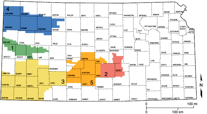
Water Related Organziations in Kansas
Kansas has five groundwater management districts (GMD) which are local units of government and provide water-use administration, planning, and information. You can learn more about each GMD by going to their websites depicted in the GMD contact information below.
|
Katie Durham, Manager |
Tim Boese, Manager |
|
Mark Rude, Executive Director |
Shannon Kenyon, Manager |
|
Orrin Feril, Manager |
Kansas Rural Water Association
The Kansas Rural Water Association provides technical assistance for Water Systems in the areas of Water Rights, Source Water Protection, Operator-In-Training (OIT) Assistance, Surface Water Treatment, Vulnerability Assessment, Emergency Planning, Water Conservation, Conservation Plans, and Leak Detection.
State Association of Kansas Watersheds
Financial Resources for Water Quantity
Financial resources are available from a variety of resources and partnerships. There are many programs and initiatives available. KACD's options include: KS Dept of Ag - Division of Conservation and NRCS.
Water Quantity Conservation Practices
 Water quantity conservation practices are implemented to reduce consumptive use, improve irrigation efficiency, and address surface water quantity concerns. You can learn more about conservation practices available to conserve water by visiting your local USDA-NRCS office.
Water Quantity Monitoring and Reporting
Flood Plain Mapping
While conservation districts and their partners at USDA NRCS address conservation resources concerns related to flooding the official flood plain maps are maintained by the Federal Emergency Managment Agency (FEMA). The FEMA Flood Map Service Center is the official public source for flood hazard information produced in support of the National Flood Insurance Program. Many local conservation districts may have paper copies of flood plain maps for their counties since the maps are continually updated through a variety of processes it is recommended to obtain up to date flood plain information online.
Kansas Department of Agriculture Division of Water Resources also maintains flood mapping data.